
Enter your email address below to follow this website and receive notifications of new posts by email:
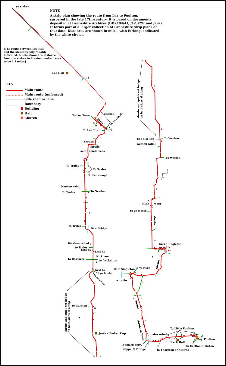
See introduction for a discussion of the provenance, dating and significance of the route displayed here and other routes in the collection of 17th-century maps and plans discovered at Towneley Hall and now held at Lancashire Archives (DDX194). Email for a GPX file of the route that can be imported to various mapping programs (I can’t work out how to add it to WordPress).
The documents in the collection include both rough sketch maps and more finished drawings. The route here is based on one of the rough sketches for which no finished drawing has been found (DDX194/27v). It links the finished drawing for the route between Ribbleton and the River Brock with the finished drawing of that between Broughton and Ellel.
The unbounded section of the route shown below, between the River Brock and the River Calder (Cawther flu on the actual document), is a best fit from the information and measurements in the original.
One probable error by the surveyors is the placing of ‘Wodacre mannor’ on the site of Dimples Hall. Woodacre Hall is nearly two miles further north. That aside the rough sketch does give a glimpse of the landscape in the area before a large part of it (Claughton Moor) was enclosed, suggesting properties to the east of what is now known as Foggs Farm and was then labelled as the property of a Mrs Fogg that no longer exist.
The original document is difficult to decipher in some places, not helped by the poor quality of my photograph. When Lancashire Archives reopens with the return to normal life after the Coronavirus pandemic is over I will check the original and, hopefully, improve my transcriptions.


A selection of some of the other items on this site
Subjects

Does the district known as Little Ireland that was firmly established in Preston by the middle of the 19th century qualify as a ‘ghetto’? It was home to Irish immigrants attracted by the town’s employment opportunities and driven by the famine that was devastating their country. See Irish ‘ghettoes’ in 19th-century Preston

When the 1871 census seemed to show just how much land was held in so few hands the Radicals were jubilant. The Conservative Earl of Derby was prodded to stand up in the House of Lords to demand a recount by way of a government survey. The result showed who owned most of the land in Lancashire. See Who owned Lancashire?

Desirable Dwellings
– Nigel Morgan’s ‘lost book’: the best guide to middle-class housing in Victorian Preston and a detailed source for the social history of the town. Rediscovered only very recently. See Desirable Dwellings – Nigel Morgan’s ‘lost book’

Why did so very few conscripts from Preston’s working-class districts find a place in the officer’s mess, and what does it say about the class divide in Edwardian Preston? See Great War conscription and Edwardian Preston’s ‘class ceiling’
.
More articles
People

The diaries of Thomas Bellingham (above) and Lawrence Rawstorne open a window on life in 17th-century Preston, and reveal the web of family and social connections that enabled the gentry to govern Lancashire. See Bellingham/Rawstorne diaries

From the back streets of Preston to the back streets of Farnworth by way of Cambridge and headship of Rivington Grammar School, the life of Septimus Tebay is a remarkable story of clogs to clogs in one generation. See Septimus Tebay — maths prodigy

A number of Catholic priests from Preston volunteered to serve as army chaplains in the Great War. They included Fr Bernard Page who saw service on the Western Front and in revolutionary Russia. Clerics in khaki

Alexander Rigby, one of the key figures in the Civil War in Lancashire, never let principles get in the way of a good deal: he was ‘never knowne to bee worth one [thousand] till hee became a publicke robber by law: but you must remember hee had beene a lawyer and a bad one.’ Alexander Rigby and his family.
More biographies
Places

Kim Travis has traced the history of the Tulketh district of Preston and its hall from pre-Norman times up to the present day. It is a marvelously detailed reconstruction. See Tulketh and its hall.

One of the foulest of the many obnoxious trades of Victorian England was the tanning of leather. The Dixon family of Bank Parade, Avenham, developed Preston’s largest tannery on their own doorstep. See Frenchwood Tannery.

Preston’s claim to have created Britain’s first public park with the opening of Moor Park in the first half of the 19th-century was, some years ago, called into question by a leading academic. Was he right? Preston’s first park.

Bow Lane, the Preston address of Lancashire Archives, was earlier named Spring Street. Even earlier it had a somewhat indecorous name. See Stand Prick Lane.
More of Preston’s historic places
Maps and Plans

Preston Market Square in the later 17th century. Find this and other plans of the town at that date here.

A plan of the route to Inglewhite from Ribbleton in the later 17th century. More Lancashire road plans here.

Plan of Preston in 1774 showing the holdings of the principal landowners. The 1774 Preston survey.

Map shows what the road network round Preston might have looked like in the late 11th century. Note no Walton bridge. Preston after Domesday