
Related article: Conflicted sexuality in Edwardian Preston
A brief reference in an 1818 Preston trade directory and a mere speck on an 1822 map of the town are the first indications of the establishment of what was to become a substantial enterprise that seems to have escaped the notice of the town’s 19th-century chroniclers.
It would most certainly not have escaped the notice of its neighbours, quite simply because it would have stunk to high heaven. For this enterprise was the Frenchwood Tannery which came to occupy a substantial site on the boundary between the then newly-developed fashionable Avenham and the meaner streets of Frenchwood. It also made the fortunes of two Preston families: the Tomlinsons and the Dixons.
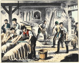
The tanning industry was one of the foulest of the many vile trades practised in Victorian England. It involved the conversion of hides and bones from the slaughterhouse into leather, glue and tallow and required the use of vast quantities of animal faeces, urine and other noxious substances. These were used in the tanning pits in which the hides were steeped. The smell would have been appalling.
It is therefore more than a little surprising that many of Preston’s most affluent 19th-century residents should have chosen to live in close proximity to the town’s biggest tannery. Yet the inhabitants of some of the most desirable addresses in middle-class Avenham would have been close neighbours of the tannery. These neighbours would have included Joseph Livesey at his home in Bank Parade. Even the gentry of Winckley Square and cotton magnate Samuel Horrocks in his Lark Hill mansion would not have been spared the stench when the wind was in the wrong direction.
It was not the tannery’s fault. It was well established at a considerable distance from the nearest properties before suburban Preston began its spread south across the Avenham fields.
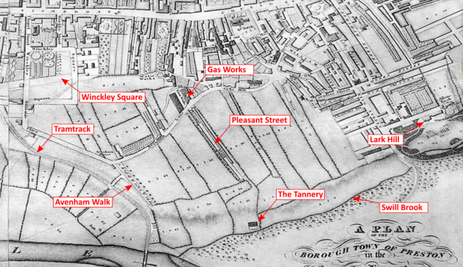
The first reference to the tannery comes in an 1818 trade directory which lists a George Thompson as operating a tannery at ‘Plantation’. This is probably the Plantation Tannery that an 1829 directory locates in Pleasant Street, the first street developed on the land south of Avenham Lane and possibly the most inappropriately named street in the town, given that it had the tannery at one end and the town’s gas works at the other.
There is no sign of any building on the site on Shakeshaft’s 1809 map of Preston, so the tannery was presumably built at some time between then and 1818. The first physical sign of the tannery appears on the revised 1822 Shakeshaft map of the town where a small industrial building and yard sits above the Swill Brook that would have carried the tannery’s effluent the few hundred yards downstream to the Ribble. By this time the tannery would seem to have changed ownership for the firm of Thomas Tomlinson and Son was now listed in a trade directory as operating as fellmongers and tanners at Avenham Fields.
The Tomlinson involvement with the tannery and with the town’s leather trade can be traced in trade directories. A Thomas Tomlinson first appears in a directory of 1811 operating a shoe warehouse in the Market Place (the address is later given as 5 Cheapside but it is probably the same premises). The warehouse is additionally described in an 1822 directory as the location of a boot and shoemakers, a curriers and leather cutters and a tanners.
In 1824, Thomas Tomlinson, tanner, was living at Pleasant Cottage (in Pleasant Street?). In the same year a William Tomlinson is listed under various directory headings as a currier, boot-top maker and proprietor of a shoe warehouse, all based at 5 Cheapside.
Thomas Tomlinson appears in an 1841 directory as a tanner at Frenchwood Tannery, as the tannery had now come to be named. A William Tomlinson appears in the same directory amongst ‘Gentry and others’, his address given as Frenchwood Place. These Tomlinsons were the Thomas and William who owned the extensive lands to the north of the town on which the Plungington estate was built.

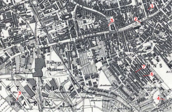
The tannery had extended considerably by 1849, judging by its appearance on the 60 inch Ordnance Survey map above. The map shows how elegant Preston had spread southwards with the appearance of Bank Parade, Bushell Place and Avenham Hill, a substantial villa set in extensive landscaped grounds. Housing had also spread alongside Pleasant Street to reach the tannery and it was Pleasant Street that supplied the only access to the tannery at this time. The narrow street must have witnessed a constant progression of carts to and from the tannery, many with foul-smelling cargoes.
Immediately to the west of Pleasant Street was Russell Street, a particularly narrow thoroughfare that marked the boundary between two very different communities, or, as Nigel Morgan puts it in his Housing in Victorian Preston1: “From Land Tax and Census records we learn that Frenchwood Street and Great Avenham Street were inhabited by shopkeeping, corn-dealing and cheese-wholesaling sort of people, nearly half of whom owned their own homes. Eastwards, beginning with Russell Street, the houses were nearly all rented to poorer families, many of them cotton weavers.”
In 1850, following the death of William Tomlinson, his estate, including the tannery was auctioned: ‘Lot 1, the tan-yard, currying works, &e., comprising 12,271 square yards of land, was sold to Mr. Richd. Dixon, for £2,350’ (Preston Chronicle, p4, 5 October 1850).
Richard Dixon had previously operated a large tannery at Dilworth, near Longridge, and for some years had been active in the leather trade in Preston. From at least 1824 his business was based Nile Street, but by 1829 it had transferred across the road to 138 Church Street, at the corner with St John’s Place next to the Parish Church.
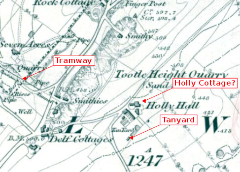
Richard continued to operate his tannery at Dilworth. Samuel Lewis’s A Topographical Dictionary of England 2 of 1848 has an entry for Dilworth, near Longridge, which describes the township as possessing just two industries: the Tootle Height stone quarries and an ‘extensive tannery’. This tannery would be Richard Dixon’s business as he is the only resident mentioned in the entry: ‘Holly Cottage is the residence of Richard Dixon, Esq.’ Dilworth was not as remote from Preston at this time as its geographical location would suggest. The Preston and Longridge Railway Company’s tramway opened in 1840 linking the newly opened Tootle Heights Quarry at Dilworth to a station at Deepdale, near the prison. This would have made it easy for Richard to transport his tanned hides to his curriers’ business in Church Street.
In 1851 Richard Dixon, now aged 53, was still living with his family at Holly Cottage. His household consisted of his wife Mary, aged 29, sons Richard, aged three, and Edmund, aged one, and three servants. For some reason both boys were given the same second name, Basset. Richard is described in the census return for that year as a tanner employing 17 men, a currier employing 18 men [in Preston?] and as a farmer of ‘52 acres stated measure’ employing four men. His place of birth is given as Brindle, his wife’s as Staffordshire and his sons’ as Dilworth. This means he was probably settled in Dilworth by at least 1848, when Richard junior was born.
Richard’s career in the 1850s can be traced in trade directories. He seems to have continued at Dilworth tannery until some time before 1855, when he is listed as the operator of Frenchwood Tannery, with no mention of the Dilworth tannery. By 1857 he had also moved his family from Dilworth to Preston, settling them at 5 West Cliff Terrace.
According to the 1861 census returns the Dixons were living at No 1, West Cliff Terrace. Richard was now 64 and his wife 49. They had three sons, Richard Basset, 13, Edward Basset, 11, and James Basset, 9, all born at Dilworth and all described as scholars. At this time the family was managing with just one servant. In 1869 they moved to 14 Starkie Street followed by a move some time before 1873 to 15 Bushell Place. Richard junior had now left home, he is listed as tannery manager, living at 2 Starkie Street.
An insight into the operation of the tannery at this time is furnished by evidence that Richard senior gave to the Parliamentary Commissioners investigating River Ribble pollution whose report was published in 1870:
“My tanyard is situate on the Swill brook, which flows into the Ribble, about 300 yards below the tanyard. Employ 26 hands. Rateable value 95l. 10s.The condition of the brook has improved, but it is polluted by town sewage. Obtain supply of water from waterworks and from springs. Consume, yearly, 1,368,000 gallons. Use yearly, lime 45 tons, bark 250 tons, gambir [an extract of a South-East Asian shrub used in tanning] 58 tons, and pigeons’ and fowls’ dung, 268 bushels. Obtain in ‘depilation’ 14 tons of hair, and about 52 tons of ‘fleshings’ which are sold and removed from works. Have 216 tanpits, 6ft. 8in. by 5ft. by 5ft., nine limepits, six waterpits, and three hair dung pits. Do not dye. All the liquid refuse produced flows through a trough over the brook into tanks, which are emptied by the tenants of the adjoining land, and used as manure. Use steam, 8 horse-power. Consume 195 tons of coal; make 25 tons of ashes, which are used in repairing roads. The excrements of workpeople are used by tenant of adjoining land as manure. No suggestions to offer.”3
Richard places the blame for the pollution on the town’s sewage flushed down Swill Brook. All the effluent and waste from his tannery, he proudly states, is recycled, none polluting the Ribble.
Richard died in 1874. Two years later his youngest son, James married Emma Seed, aged 22, by which time he and his brother Richard seem to have taken over the business which later is listed as Dixon Brothers. The tannery was not their only business activity, they were also dabbling in railway shares: their names appear on an 1875 list of shareholders in the Grand Trunk Railway Company of Canada.4

On the map above can be seen the extent of Avenham development at the end of the 19th century. The 1881 Census records Richard, now aged 33, living at Oak House, Frenchwood Street, with his 28-year-old wife, Annie, his daughter Annie, aged nine, son Richard, aged six, a cook and a housemaid. Richard is described as a tanner employing 27 men. His brother James, now 29, was living at 15 Bushell Place with his wife Emma, aged 27, and two servants. He is described as a farmer. The firm of Dixon Brothers is listed as running the tannery in directories for 1882, 1885 and 1889. In the same directories Richard Dixon is listed as living at Oak House, Frenchwood Street, and James is living at 15 Bushell Place.

It is interesting that Richard chose to live at Oak House, which presumably he had had built, for it was directly adjoining the tannery and would have been subject to all the smells, flies and vermin that it produced. Access to the tannery by this time seems to have switched from Pleasant Street to Frenchwood Street, so the procession of wagons would now be passing the house to reach the tannery. The trend by this time was for owners of mills and factories to put some considerable distance between residence and workplace, so why did Richard not choose a more salubrious address?
Richard died in 1890, aged 42. His son Richard had died the previous year, aged 14. The census returns for 1891 set out the household of his widow Annie at Oak House: she was now 37 and head of the household, ‘living on her own means’, with her daughter Annie, aged 19, single and also ‘living on her own means’. They are looked after by a cook, a housemaid and a nurse. Mrs Dixon was still living at Oak House in 1895 and 1898. Her brother-in-law James, now aged 39, was also ‘living on his means’ at 15 Bushell Place in 1891 with his wife Emma, aged 37, and their five-year-old son Ernest (known by his second name,Leslie), plus a cook, a mother’s help and a general servant.

By 1895, James had moved to 14 Ribblesdale Place, later named Ribblesdale House, leading the life of a leisured gentleman and sending his son, Leslie, to Rugby School and on to Oxford. 5 Leslie was involved in what could have become a homosexual scandal shortly after leaving Oxford; details here.
Ephemeral scraps give some indication of James Dixon’s pursuits. Gardening was clearly one of them for in December 2015 a Silver Prize medal of the Gardeners’ Magazine awarded in 1891 to James Bassett Dixon for ‘Excellence of Culture’ was for sale on ebay for £48. His other interests included the study of molluscs, judging by his listing in 1906 as a member since 1892 of the Conchological Society of Great Britain and Ireland6. He died in 1909.

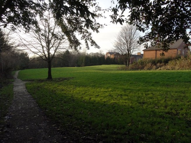
James’s death also saw the end of the tannery. Its buildings appear intact on the 6 inch OS map of 1895 but by 1912 the tannery site had been cleared as the above OS map shows. Since then it has remained undeveloped and is now a grassed over space, unrelieved by any landscaping.

Sources
Most of the information for this article was garnered from the excellent collection of trade directories at Preston’s Harris Library, supplemented with 19th century maps and census returns. A very useful guide to the wider Frenchwood area was produced by Preston Council, including a very well written account of its development by Margaret Burscough: Tales of Frenchwood (Preston: Preston City Council, 2009).
Other sources utilised in the article are:
- Copies of Nigel’s ‘An Introduction to the Social History of Housing in Victorian Preston’ can be found at the Harris Library and at the County Record Office. The quote appears on p19
- http://www.british-history.ac.uk/report.aspx?compid=50920
- pp 162-3 Reports from Parliamentary Commissioners, vol 40 1870. Available from Google Books https://books.google.co.uk/books?id=kCtcAAAAQAAJ
- http://archive.org/stream/cihm_06588/cihm_06588_djvu.txt
- Arthur Tompson Michell, Rugby School Register, 2nd ed., vol. 3 (Rugby: privately published, 1904), 273, http://archive.org/details/rugbyschoolregis03r
- http://archive.org/stream/journalofconchol11190406conc/journalofconchol11190406conc_djvu.txt

Hello,
You contacted me at Ancestry. I have done extensive research regarding a member of the Dixon family directly related to those in your research. I enclose the link to my work.
I hope this is of some interest.
Best regards,
Ian Waugh
http://ianwaugh.com/2015/05/29/the-red-tie/
LikeLike
Very much enjoyed reading this excellent article! My maternal family (Seed) lived on Manchester Road from the early 1900’s and my Grandmother was born on Brunswick Street so they must have been aware of this tannery!🙁
LikeLike